
Impossible Roads. There is a special anticipation and excitement looking down a road that is clearly impossible. The map says there is a road but the eye, the mind, and common sense do not believe it for a moment.
Then you continue and find a road that exploits the natural contours of the land but ultimately demonstrates man’s total control of the environment. When you finally finish a thousand feet or more higher and look back at a magnificent vista of your approach, there is a real exhilaration and respect for the people that carved these roads; usually in the days when this was done by eye, dynamite, mules, and human sweat.
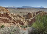
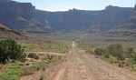
The top photo is the view back from the top of the Burr Trail looking back at the Henry Mountains and the picture below is the view as you approach – the trail is totally invisible. This road was carved in 1876 by John Atlantic Burr to allow him to move cattle between winter and summer pasture and to market across the Capital Reef – a hundred mile outcrop of rock.
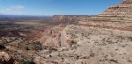
The other small picture is the approach to the bottom of the Shafer Switchbacks that lifts you from the edge of the White Rim Trail up a thousand feet to the Island in the Sky and thence back to Moab, Utah.
The final image is the Moki Dugway and the road that approaches it from Mexican Hat, Utah. This road is much more modern having been built in 1958 to allow transport of uranium ore from the “Happy Jack” mine in Fry Canyon to the processing mill in Mexican Hat. The term “moki” comes from a term used by the 18th century Spanish explorers to describe both the Pueblo indians they met and their vanished culture.
