A Short History of the Equator.
The Greeks started the ball rolling on the process of understanding the shape of the Earth. Pythagorus suggested that the Earth could be a ball in space; Eratosthenes designed a method for calculating the size of the ball in space by measuring arcs on a meridian and the angles to the sun; Hipparchus designed the 360 degree grids of latitude and longitude for the ball in space. All this before 300BC. Then the world got religion – one religion after another starting with Christianity – and everyone was told to believe the world was flat and filled with fire and brimstone for those who thought otherwise.
Then the compass came along around the 12th century and allowed reliable long distance maritime navigation. When Columbus got his navigation horribly wrong, the Spanish didn’t mind because they found rich new lands, but his error did point out that world was way bigger than previously assumed and the new science of geodesy was born – the effort to know the exact size and shape of the globe.
By the early 18th century the debate had settled into another France vs: England spat – was Isaac Newton right that gravitational effects would cause the rotating globe to bulge at the equator or would Rene Descartes be right that particles streaming from the Sun would carry all the planets and cause the globe to be slim waisted. A lot of national pride was at stake here. In the 1730s the French Academy of Sciences sent teams of scientists to Lapland and to South America (Ecuador wasn’t called Ecuador yet) to measure their arcs and figure this out.
It is hard today to imagine how arduous it must have been to travel from France to the west coast of South America and then the terrifying mule train to Quito over rope bridges and along sheer cliffs. Their work took years, infighting took its toll on the delegation, and only five out of the original nine members made it back to France.
(Spoiler Alert) Newton was proved right. Earth has a bulging waistline.
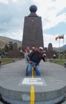
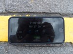
The monument on the site of their work today, celebrating both the French and Spanish geodesics, was built around 1980 and the line of the equator, that has been the axis for so many photographs, is actually 250 meters from where it should be. Still an astonishing level of accuracy for the technology of 1736.
Photos: Group shot across the equator – Modern measurement proving the misplacement of the line.
