
From Quorn to Adelaide – A Ride Through Science and Time
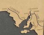
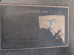
In 1865, George Goyder the Surveyor-General of South Australia rode over 3000 Km to develop a map that would help farmers decide where they could plant crops. He drew a line across the colony that roughly corresponded to 10 inches of rain per year and declared land to the north “liable to drought” and to the south safe for arable farms. Some farmers ignored his map and planted to the north as they believed in the popular doctrine from the US West that “rain follows the plough” but this fallacy led to them abandoning their farms
Today, a century and a half later, this delineation is still very much obvious and a testament to a wonderful piece of science given the resources at the time.
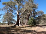
We left Quorn and rode through dry, lifeless scrub with no grass and very little other vegetation but within 30 Km we started to see gum trees with their mangled and gnarled trunks in the creek beds where there is occasional water. By the time we had gone 50 Km, we were in rolling grass and farmland and after that perfectly curated wine country.
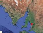
There is a small marker to honour Goyder near Mount Remarkable in Melrose and, looking at the latest Google Maps satellite picture, it is clear that the line has moved south as the climate has warmed and dried. Something Goyder could not have foreseen.
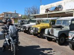
This route is such a pleasant jaunt. It takes you through an Australian time warp – like someone set the dial back to 1965. The townships were all perfectly preserved from another epoch and we did not see a single “big box” store in any of the towns. The general store in Georgetown was not a museum piece; just still the hub of the town with everything that anybody needs that nobody has updated for decades. I asked the shopkeeper serving Bill about business and he said “Well I can still eat”.
We didn’t let Michael into the Wilmington Toy Store as he was salivating.
