


Monuments and Fences
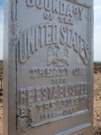
The border with Mexico and Texas was established as the Rio Grande in 1836. After the Mexican-American War in 1848, Mexico ceded huge amounts of land and in 1853 the US bought more from Mexico (the Gadsden Purchase) and a new border had to be defined – an imaginary line across the desert.
A team of Mexican and American surveyors, astronomers, and scientists were dispatched to jointly survey and install border monuments to mark the agreed line. Eventually 276 of these were installed regardless of the terrain and the fact that nobody at the time imagined that this line, in such a desolate and useless part of the world, would be of any importance. They really got that wrong.
We tried to get to Border Monument Number 1 in El Paso but this is now almost impossible to visit given the lunacy of the wall placement. The monument is where New Mexico meets Texas meets Chihuahua on the Rio Grande. Technically it is in New Mexico on US soil but the wall/fence that cuts El Paso was installed a few hundred yards to the north. To get to the monument requires a crossing to Mexico and an exploration of the poorer slum areas of Ciudad Juarez which we were NOT willing to try.
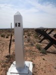
Further west in New Mexico we found the fence and Border Monument 12 and onwards. Very few of these are original – this one was repaired in the 1960s with a cast metal obelisk with rings to install a flag pole (not sure whose flag is supposed to fly) and embossed warnings not to damage it.
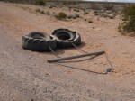
The fence runs laser straight with the road alongside for border patrol to drive and where they periodically drag old tyres to clean the sand and make it easier to see new footprints. We met Border Patrol agents along the way as we have done several times and they were genial and helpful and wished us a safe ride. No hassles. Good PR.
It was also interesting that they used the monument numbers to describe the sectors of the fence “It’s real pretty out there by monument 41” We’re heading there next.
