Caballitos de Totora – Little Reed Horses

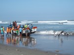
Caballito is Spanish for sea horse and these reed fishing boats are ridden like horses into the water by fishermen in Pimentel; a small rustic village on the coast by Chiclayo, Peru. This technique predates any European contact – though the addition of styrofoam in the stern probably came later. I talked to one fisherman who told me that they land anything from anchovies to shark.

That morning a more practical form of fishing was rolling in the surf and selling its catch to those that gathered on the beach; including a few expectant pelicans who did get a share.

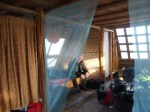
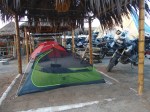
We ended up in Pimentel after a vague call to “sleep on the beach” after an ugly haul away from the border. We rode 400 miles down the PanAmericana highway which here is straight, windy, hot, and boring across the coastal desert and the “fast group” hit upon a camp that was a cross between the Whole Earth Catalogue and Burning Man. Some decided that their tents were a safer flea-free environment than the pyramids. If Peru has a Spring Break equivalent, I bet it’ll be happening here.

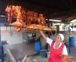
Most astonishing was the fact that our host produced the best meal we’ve had so far – couple of fresh fish cooked two different ways and chicken and salad and BEER.

They Call It Rain Forest For a Reason.

The geography of South America is pretty simple; the continent only has three parts – the Amazon,  the Andes, the Rest. Alright, it might be a bit more complicated than that; the Rest is made up of the drier parts of Brazil, plus the Pampas in Argentina, plus Patagonia. Still pretty simple.

For Expedition65 we decided to essentially travel down the Andes from the top of South America to the bottom. We will, however, be zigzagging a little bit and drop officially into Amazonia a couple of times. Today we headed east from Baños in Ecuador across South America’s continental divide in the dramatic canyon along the Pastaza River which is one of 1100 tributaries that drain into the Amazon.

The weather was absolutely foul – heavy rain for several hours as we made our way south in the rain forest towards Cuenca. The rain went from acute to chronic but never stopped. All the rivers were in full flow bubbling over rocks and ripping sediment in a brown swirling soup.

All the rain that did not spend its energy on soaking us to the skin, shortly ended up in this river and will, about a month from now, spill out into the Atlantic Ocean, about 5,000 miles downstream.

The first person to make the same journey downstream was Francisco de Orellana in 1541. He set off in search for food for Pizarro’s marauding conquistadors but got mesmerized by the potential of what he saw and then, as they all did, took off in search of El Dorado which he thought was in the jungle. A few months later his party was attacked by an indigenous group that claimed a female god as their leader and he was convinced that they were being attacked by women. He later then named the river after the mythical women warriors of ancient Greece – the Amazons. After eight months he arrived at the Atlantic and became the first European to travel the length of the Amazon. Nobody else would manage to do this again for a hundred years.

Ecuador Highlands; Closest to Heaven.

Today our hosts, The Brosters, led us from Quito to Baños by circling the volcano Chimborazo on dirt roads and we got a real sense of the landscape, the indigenous people, and the real Ecuador.

First Chimborazo. When the German explorer, Alexander von Humboldt, and his French assistant, Aime Bonpland, climbed and surveyed this mountain in 1802 it was thought to be the highest mountain in the world. It is, in fact, the highest peak from the centre of the earth due to the bulging waistline of the Earth. In Ecuador they say it more poetically; Ecuador is the piece of the world that is closest to heaven.

More recently we have adopted mean sea level (MSL) as a datum for measuring altitude because altitude from sea level measures what humans care about – oxygen.

Here, in the Avenue of Volcanoes in norther Ecuador from Quito to Cuenca, running between the two cordilleras of the Andes, there are seven peaks over 17,000 feet and they are, in fact, ALL further from the centre of the Earth than Mount Everest. (*)

One of the amazing effects of these massive volcanoes is that they mess with the climate. On the west side is arid desert and on the rainy east side there are huge tracts of lush, green cattle ranches. We bumped into indigenous people living very different lives on the different sides. As we rode past Chimborazo it SNOWED.

On the dry side – a woman coming back from shopping carrying her purchases on a mule many miles from anywhere; a group of farmers tending sheep and llamas on land that can barely support life. On the wet side – a weekend rodeo of horsemen roping calves decked in gaucho gear that probably hasn’t changed in centuries. We stopped and mingled and took photos and met a number of spectators and watched the horsemen who were universally shit-faced drunk on some kind of local moonshine before they entered the ring to try and rope calves.

A Short History of the Equator.

The Greeks started the ball rolling on the process of understanding the shape of the Earth. Pythagorus suggested that the Earth could be a ball in space; Eratosthenes designed a method for calculating the size of the ball in space by measuring arcs on a meridian and the angles to the sun; Hipparchus designed the 360 degree grids of latitude and longitude for the ball in space. All this before 300BC. Then the world got religion – one religion after another starting with Christianity – and everyone was told to believe the world was flat and filled with fire and brimstone for those who thought otherwise.

Then the compass came along around the 12th century and allowed reliable long distance maritime navigation. When Columbus got his navigation horribly wrong, the Spanish didn’t mind because they found rich new lands, but his error did point out that world was way bigger than previously assumed and the new science of geodesy was born – the effort to know the exact size and shape of the globe.

By the early 18th century the debate had settled into another France vs: England spat – was Isaac Newton right that gravitational effects would cause the rotating globe to bulge at the equator or would Rene Descartes be right that particles streaming from the Sun would carry all the planets and cause the globe to be slim waisted. A lot of national pride was at stake here. In the 1730s the French Academy of Sciences sent teams of scientists to Lapland and to South America (Ecuador wasn’t called Ecuador yet) to measure their arcs and figure this out.

It is hard today to imagine how arduous it must have been to travel from France to the west coast of South America and then the terrifying mule train to Quito over rope bridges and along sheer cliffs. Their work took years, infighting took its toll on the delegation, and only five out of the original nine members made it back to France.

(Spoiler Alert) Newton was proved right. Earth has a bulging waistline.

The monument on the site of their work today, celebrating both the French and Spanish geodesics, was built around 1980 and the line of the equator, that has been the axis for so many photographs, is actually 250 meters from where it should be. Still an astonishing level of accuracy for the technology of 1736.

Photos: Group shot across the equator – Modern measurement proving the misplacement of the line. 

Intro to Ecuador

As part of the strange and wonderful brotherhood of worldwide adventure motorbike riders, we are fortunate to be hosted in Ecuador by The Brosters – the country’s BMW riders club in Quito. These guys have opened their arms, decided to show us all that Ecuador has to offer, and provide hands on support for our time here. More on The Brosters later. 

Near Ibarra is Laguna Yahuarcocha, the Lake of Blood. In 1487, after their defeat of the Caranquis, the Inca king Huayna Capac ordered that all their males over twelve years old were to be killed and 30,000 bodies were dumped into the lake turning it red with their blood. Today it is a pleasant picnic and recreation are that includes – a race track.

The family of one of the Brosters led the effort to build the track in the 1960s and we gained access for a couple of hours. So, let’s put 15 guys on the track on BMW R1200GS bikes that have all their luggage and knobby tyres – what could possibly go wrong? Actually nothing – we had a blast and nobody crashed.

Onwards to Otavalo and Ecuador’s most important craft market. The Otavaleños have been masters of weaving and textiles for centuries and both the Incas and the Spanish exploited them and their skills. They may be respected today but the indigenous people are still at the bottom of the social and economic ladder.

Big Bikes in Small Pueblos

Whenever a group of us shows up in a small town on big bikes, we are always the centre of interest.

There just aren’t any other large motorbikes in South America – anything above 150cc causes as much stir as if a Ferrari has rolled into town. There follows the inevitable questions “Que motore?” so you have to be able to say in Spanish “Mil Doscientos” (1200cc) and then they ask “Que velocidad?” and everyone gasps when you tell them “doscientos” (200 kph). When the topic turns to the price of the motorcycle, it is best to change the subject – the cost of a new BMW R1200GS in Colombia is 4x the Per Capita GDP.

But when you show up with big bikes AND a few soccer balls donated by Nike for our trip, you get a crowd instantly. We had a great time on the ride from Popayan to Pasto in Colombia when we pulled into El Estrello and found the local soccer pitch; a dirt block way back from the main road. Within minutes there was a crowd of kids and parents and then shortly afterwards the town soccer coach heard about our appearance and he turned up with his whistle like a badge of office around his neck.

Other sights along the way – local bus with more stuff and persons piled all over it including two scooters – no lane splitting allowed but nobody takes any notice of the signs – lunch of smoked fish and chicken in an area that, even a year ago, was a FARC stronghold and their are still soldiers on every bridge to guard them against attack.

Sugar Cane in Colombia

Today we rode from Alcala in the Zona Cafetera along the Valle de Cauca that is the heart of the sugar industry in Colombia – hours of riding and nothing but sugar. The climate here is such that sugar grows all year round and is harvested constantly and transported to the processors in enormous fleets of “Tren Cañero” – cane trains – that menace the roads with five trailer behemoths.

Sugar is an industry with its tentacles wrapped around the political process that is so typical. I was tempted to say “so typical in these countries” but the process is no different in US States and Congress. An example.

The owners of land in this area amassed more land and power during La Violencia from 1946 onwards when politics exploded and the FARC took to the hills to fight on and resist. In this period millions of people were forcibly removed from around 100,000 separate properties and now one conglomerate owns the majority of the land. To bolster demand the sugar lobby has maneuvered the government to mandate sugar ethanol be mixed with gasoline. The lobby has strong media ties and has strong ties to the state, supported the last few Presidents, and helped a lot of congress get elected. Sound familiar? Cut and replace “sugar” with “corn” and this is identical to the US.

Perhaps one important difference. Maybe in the US we can claim to have countervailing forces that help prevent this level of wholesale government absorption by business interests. We have a strong and independent press that is focussed on revealing corruption and holding officials and companies to high standards of ethics and legal compliance. Oh never mind – the US is like Colombia.

Medellin – The City of Eternal Spring.

We escaped the heat and humidity of the tropical Carribean and crossed over into Medellin, wedged in a narrow valley between the Western and Central Cordillera of the Andes at a more pleasant 5000 foot altitude. The weather is Goldilocks beautiful; not too cold, not too hot, but just right all year round.

Medellin was settled late by the Spanish because it’s tough to get here. The earliest settlers were Spanish Jews escaping the Inquisition headquartered in Cartagena. Unlike the rest of Spanish South America that depended on massive imported slavery, they set up haciendas that they worked themselves. This streak of independence survives and Medellin is a modern city with real infrastructure and competent government and tons of local pride.

The recent history has been marked by the violence of the drug cartels. These guys amassed enormous wealth and here they even started to propose local public works investments and new political parties. That didn’t go down too well and the Colombian and US militaries pursued Pablo Escobar until his assassination on a Medellin rooftop in 1993. Now the city is one of the safest in the world – a fashion, industry, and party capital.  There are even Pablo Escobar themed tour operations.

That’s not to say that the drug business has gone away. The communist rebel army in the jungle (FARC) has been taking over where the cartels left off. This month the Colombian government signed a deal with the FARC to end violence that has been ongoing since 1946 but this still has to be ratified by a vote of the people.

In the face of all these troubles, the people here have a saying “Los buenos somos más” – We good guys outnumber the bad guys. Great advice but It sounds better in Spanish.

Another favorite son of Medellin is the sculptor Fernando Botero and there is a lovely park in the center of the city with a large number of his bronzes. You could call them Rubenesque but I think Botero deserves his own “esque” – these are all Boteroesque statues. It is interesting that you can see where people have been tempted to touch the statues and lightened the metal – Fonz and couldn’t help ourselves do the same thing.

One more comment about the safety and wealth in Medellin: this is the first city in South American where I have seen people cycling for recreation; mountain and road bikes and riders with all the neon lycra gear all over the city.

Baptism on the Rio Cauca – Conversion and Spiritual Cleansing.

Some days you just ask how did this happen and then you realize that everything happens for a reason. Inshallah. Leaving Monteria and the horse farm we all had bikes that were covered in hard mud from the day before.  This day we had decided to split in to smaller groups to avoid having the logistics and time consumption issues of out very large group – it takes a long time to fuel fifteen bikes.

As we tracked along the muddy and flooded Rio Cauca, we could see the beginning of the Cordillera Occidental looming up in our windshields; the very northern tip of one of the three fingers of the Andes that push up through Colombia and end, exhausted, in Venezuela and the Carribean. Along here the good people of Puerto Valdivia have been given a resource to make a living – the natural spring that flows out of the mountain and into the Rio Cauca. There are now dozens of car and truck wash businesses along the road ready to make everybody sparkling – advertising themselves with high pressure jets of water.

A real need met a perfect solution; park five bikes and stand back while they were scrubbed. They are now immaculate and there was no more mud our suits either. 

One of our number, however, took this a little more seriously than you might normally expect. I present Evan Firstman who decided this was not a menial task of motorcycle cleaning but a moment of spiritual cleansing and we all had to be converted.

Then, after doing the nuttiest thing ever, Brother Firstman decides to give a lecture on the importance of common sense maintenance to future spectators of the movie of this trip. Perfect. 

Crossing Colombia – Climate is what you expect: Weather is what you get.

The first day out of Cartagena was intended as a gentle break-in day down to the beach and then and easy ride to camp at a ranch in Monteria. Well it didn’t quite work that way when a huge tropical thunderstorm followed us across 20Km of dirt beach road and turned it into a slippy sloppy mess with water crossings as the fields drained. At one point the instant rivers were big enough to keep us from leaving and we had to wait for them to subside.

The local farmer on his mule had an easier time with the mud than our BMWs. This weather is really miserable for a lad brought up in England.

The destination was to camp at a ranch in Monteria famous for its prize Brahman bulls who we got to meet in the morning. These animals are pampered and docile and very used to being paraded and shown – they had the moves and the poses all ready for their moment with the cameras.

There’s more than one kind of bull in these photos.