Views of London. Different perspectives open different discussions.

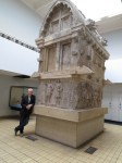
On a quick visit to London this weekend, I had a chance to get to the View from the Shard; the 72nd floor of London’s newest and Europe’s tallest building. The view is staggering and I am sure will spawn a new meme of London panoramas. This view is made of two iPhone panos stuck together in Photoshop. Looking north from the Shard across the Thames, it is amazing how London’s historic landmarks have become invisible – Sothwark Cathedral (front left) was quickly surrounded by railway lines and Borough Market; St. Pauls plays second fiddle to Tate Modern; Tower Bridge and the Tower of London have disappeared under the glass and steel of the City of London.

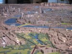
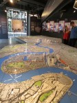
On a different scale, New London Architecture (NLA) Centre for the Built Environment, provides a complete overview of what is happening in Greater London. The Pipers Central London Model is a 1:1500 scale model of central London from Paddington to The Royal Docks and from Battersea to King’s Cross with all the new and proposed buildings called out in white. The two views here are from over Hyde Park Corner looking east past Buckingham Palace to the London Eye, the Shard and the City of London, with Canary Wharf in the far distance. The other, bigger view is from the opposite direction with the Millennium Dome (remember the Millennium?) in the foreground and looking west over over Canary Wharf, the City, then central London in the distance.

Other stuff I learned: 80% of London’s carbon emissions come from its buildings, yet 40% of London is green space and Royal Parks cover 8 square miles, and the population is expected to grow from 8.3 to 10 million people in the next 20 years.

Moving History from Lycia to the British Museum. Earlier this year we sailed along the Lycian coast in southwest Turkey with a few friends and our own archaeologist on board; Peter Sommer. Peter walked 2000 miles in the footsteps of Alexander the Great to discover Turkey when he was a graduate student and now takes groups by bus or by boat to sample the same experience. Do one of these trips and you’ll thank me afterwards.

Repeatedly, however, we would visit a site and find that much of the finest tombs and temples and artifacts were no longer there; removed or destroyed long ago by conquerors, house-builders looking for stone, or looters looking for profit. In many cases, however, they had been hauled off by Sir James Fellows on a series of visits in the 1840s to gather up antiquities for the British Museum and the walls and gardens of his wealthy patron, Lord Palmerston.

This week I had the chance to close the circle and visit the British Museum to catch up with the pieces of Xanthos that were expropriated by Sir Charles. To be fair, it seems that Lord Palmerston had, in fact, obtained permission from the Sultan at Constantinople to ship some of the artifacts from Lycia, but I doubt that the Sultan realised quite how much would have been carted off. Several ship loads as it happened.

There are three rooms in the British Museum dedicated to Xanthos and the scope is staggering. These rooms are right next to the Elgin Marbles which Greece still wants back by the way – but that’s another story,

Here you can see what Payava’s Tomb looks like in Turkey today – with Peter Sommer holding the book – and what it looks like rebuilt with the top and side friezes abducted by Fellows filled in with carved limestone. Much more stunning is the Nereid Monument which is a temple tomb from the same site. One side of the tomb is reassembled but the rest of the room contains all the pilfered pieces; absolutely amazing. No wonder there was nothing to see at Xanthos itself; every damn stone is here.

I also learned that Sir Charles (who was knighted after these trips by a grateful nation after carting off Xanthos to England) was a fellow Nottingham lad and that one of his first studies was of Newstead Abbey, the home of Lord Byron, which I used to visit very often when I was a kid and where my parents ended up living next door. Small world.

Istanbul: Ground Zero For All Our Modern Problems …

Istanbul is a staggeringly beautiful and fascinating city. It feels ancient and modern at the same time. It is booming economically but its politics could explode at any moment. It seems mysterious and exotic and distant and unimportant but this is the place that has bequeathed us conflicts that still threaten world peace. Maybe we need to learn more about what is going on here.

Constantinople was the capital of Byzantium (the successful half of the Roman Empire) for a millennium and then, captured by the Turks in 1453, became Istanbul and the capital of the Ottoman Empire for almost another 500 years after that. From Budapest to Baghdad, from the Caspian Sea to Algeria, half of the Mediterranean, both sides of the Red Sea, Greece, and Turkey. A huge area held together by force of arms and fragile, venal alliances. An explosion of wealth and splendor and influence that eclipsed and threatened Europe for most of this time.

Then in 1914 an assassination in Sarajevo by a Bosnian Serb set off the First World War and all this unravelled within a decade. Incompetent Ottoman leadership and the bungling of Britain and France exposed ethnic and religious fault lines and unleashed a century of genocide, ethic cleansing, wars, and terrorism that we will be dealing with for another century for sure.

Greeks versus Turks, Serbs versus Bosnians, Sunni versus Shia, Orthodox versus Muslim, Turks repressing Armenians and Kurds. The biggest geopolitical issues that worry and plague us today, all have their roots in the breakup of the Ottoman Empire – Russia competing for Ukraine, Islamists fighting for a Caliphate in Syria and Iraq, the failed Arab Spring, Benghazi, and, of course, Palestine.

A fascinating place to visit and learn about for sure. Oh. and the food and the wine and the beer and the people and the public transport and the museums and historic sites are all wonderful.

Flying Monkeys…… Riding through Greenville this morning on California Highway 89 just south of Mount Lassen, we saw this sign that said “Leathers, Denim, Coffee”. Not a sign you can pass.

At Flying Monkeys we had an absolutely delightful visit with Chris Biggs who sells leathers to bikers and denims to loggers; or the wannabes in each category. He shared his coffee and his life story and provided a quirky and funny update on the history and outlook for this town.

Chis raced bicycles in France until a cycling accident put him in a wheelchair, he opened a Vanson leather dealership when living in Hamburg for ten years selling leathers to the Germans who loved British bikes, he moved to Greenville in 2000 and opened this store a couple of years ago, his buddy Bobby dropped in when he saw our bikes, Bobby “hasn’t been the same since ‘Nam”, told us he used to ride with his pals and pass the whisky between bikes until the cops pulled them over and said “You can keep the bottle but I’ll take the keys”, the guys in town with dead eyes and no teeth are making and taking meth, the Indians get all this government money and just drink it, not much work for loggers any more but they still hang around, used to be a load of mills around here processing ore but no more, he tried to get local kids into the garage and teach them mechanical skills but they weren’t interested, “shoulda been better than staying at home with Dad drunk on the sofa”.

You cannot make this stuff up and we could have stayed there all day swapping stories. If you are ever on Highway 89, make sure you drop into Flying Monkeys.

Impossible Roads. There is a special anticipation and excitement looking down a road that is clearly impossible. The map says there is a road but the eye, the mind, and common sense do not believe it for a moment.

Then you continue and find a road that exploits the natural contours of the land but ultimately demonstrates man’s total control of the environment. When you finally finish a thousand feet or more higher and look back at a magnificent vista of your approach, there is a real exhilaration and respect for the people that carved these roads; usually in the days when this was done by eye, dynamite, mules, and human sweat.

The top photo is the view back from the top of the Burr Trail looking back at the Henry Mountains and the picture below is the view as you approach – the trail is totally invisible. This road was carved in 1876 by John Atlantic Burr to allow him to move cattle between winter and summer pasture and to market across the Capital Reef – a hundred mile outcrop of rock.

The other small picture is the approach to the bottom of the Shafer Switchbacks that lifts you from the edge of the White Rim Trail up a thousand feet to the Island in the Sky and thence back to Moab, Utah.

The final image is the Moki Dugway and the road that approaches it from Mexican Hat, Utah. This road is much more modern having been built in 1958 to allow transport of uranium ore from the “Happy Jack” mine in Fry Canyon to the processing mill in Mexican Hat. The term “moki” comes from a term used by the 18th century Spanish explorers to describe both the Pueblo indians they met and their vanished culture.

The White Rim Trail in Utah’s Canyonlands … Don’t let anyone try to tell you that this is an easy/intermediate ride; it is not. It is one of the most challenging and exciting and spectacular ride as you will find in America. As soon as you drop into the Green River, the next 90 miles demand your full and undivided attention.

After a few days of thunderstorms we found lots of water and mud, miles of sand, and teeth rattling rocks. There are also two very scary climbs and equally challenging descents over Hardscrabble Hill (says it all) and Hogs Back. The climbs are steep, rocky, twisty and require total commitment – no way to stop half way for a breather and to pick a line.

Overall there are hundreds of places to screw up and a couple of dozen places where it would be easy to accidentally imitate Thelma and Louise.

Pictures: – Spectacular rock towers, me overlooking the towers, the gang that made the circuit, the gang at lunch, and a wider look at our lunch spot. The rock edge of the left is the trail itself with an abyss to the right. 

An amazing day after which I visited neither the Emergency Room nor the BMW parts department. May be a first.

With: John Peluso, Kurt Huppert, Joe Cassin, Ralf Fischer, and Dave Ulsh.

Monument Valley – has been used in so many films that it seems to define how we think of the American West.

John Ford shot “Stagecoach” here with John Wayne and then returned nine more times and there is now John Ford’s Point in the park in his honour. Since then there has been “Easy Rider”, “Electra Glide in Blue” and “Thelma and Louise” and Stanley Kubrick used Monument Valley as the surface of an alien planet in “2001: A Space Odyssey”. And who can forget the running scene in Forrest Gump where he stops running on US Highway 163 with Monument Valley as a backdrop and says “I’m pretty tired. Think I’ll go home now”.

We passed through there today and rode the 17 mile dirt road loop road inside Monument Valley this is entirely within a Navajo Nation Tribal Park. The road is a pretty rough ride even on a BMW GS with rocks and a lot of deep sand, but the views were spectacular and enhanced by the drama of a huge storm blowing through.

Snapshots from Lesotho.

Lesotho is a country landlocked inside South Africa. It was once Basutoland, a British protectorate since Queen Victoria agreed to keep it from the Boers and independent from Britain, other than having Marmite in the shops, since 1966. It is one eighth the size of Oregon with a GDP half that of Bend, OR. Its main employer is the garment industry that services the usual global brands with cheap labour and its largest natural resources are diamonds and water.

We saw none of this of course as we crossed the country’s primitive rural backwaters on a ride from Sani Pass on the east side in the Drakensberg Mountains to Butha-Buthe in the north-west across another range – the Maluti Mountains. Along the way we got a glimpse at the part of the country that is not seeing benefits from Wal-Mart employment or diamonds or running water.

The road from Sani Pass is being rebuilt completely by the low-cost bidder – China. We saw miles and miles of blasting and manhandling of rocks – every vehicle registered in China, with Chinese supervisors and Lesotho hard labour. The kids were running along a section of new road for what looked like school Physical Education class – all happy to be let loose but most without shoes.

The road from Mokhotlong to Tsaba-Tseka is listed as a “Fair Weather” road. It is certainly untouched by Chinese road builders and is either your worst driving nightmare or the most exciting and challenging BMW GS experience in your life – or both. We made it without any bikes being dropped but the overall journey took 8 hours for 200 Km. What a blast!!!

The huge majority of the housing we saw consisted of the traditional thatched roundhouses. Many of them now have shiny corrugated tin outhouses with vents that connect to the pit below – I am sure this is a huge public health improvement and the only innovation that distinguishes the houses from those made centuries before. The chap cleaning a sheep’s head in the river before cooking was in the river here.

Every Lesotho adult was wearing a traditional blanket as their principal garment – all sorts of designs and styles but everywhere a blanket, The horsemen here are modeling very typical garb and I have no idea if the different designs signify any kind of rank or status or just style and wealth points.

Finally we were totally awed by the scenery and grandeur of these huge river valleys between magnificent mountains. It is stupendously beautiful and every hill and pass revealed another more breathtaking vista. The one panorama here shows our road as a thin scar across the right side overlooking the river valley below.

One more comment about water. Every map of Lesotho we found to be hopelessly inaccurate. The one shown here hanging on the wall of the hotel shows the road we took perfectly but shows it going through a reservoir that does not yet exist – because the Mashai Dam has not yet been built. I hope someone tells the people living there that they are going to be getting running water pretty soon – but not the kind they wanted.

Meet Hubert Kriegel

Just when you think you are a pretty hard core adventurer, heading up one of the highest road passes in Africa after days of rain has turned the surface into mud, you meet this guy coming down the other way – riding his Ural in an old ski jacket, no socks, and deck shoes in crazy red glasses and an open face helmet that looked like it pre-dated internal combustion.

Frenchman, Hubert Kriegel chucked it all in and took off in 2005 on his motorbike from his job in New York – originally on a KTM and now a Ural. Across the USA, up to the Ice Road in Alaska, down to Ushuaia, around Europe, months in Mongolia, and the length and breadth of Africa. Now he is heading to Cape Town to get a boat to India and onwards.

He said that Africa was too restrictive for his sense of freedom and adventure “customs officials let you in and all they want is for you to get out” of their country.

Checkout his story “Ten Years on the Road! Sidecar-ing the world horizontally and vertically”. www.thetimelessride.com

Isandlwana and Rorke’s Drift.

1879 Britain decided to consolidate a few more chunks of Africa; it worked in Canada so why not here? First order of business was to annex the independent Zulu nation and 15,000 troops were sent off to get the job done. The first encounter was at Isandlwana and turned into Britain’s equivalent of the Battle of Little Big Horn – a far superior military force with arrogant leadership was duped into splitting its forces and was soundly punished; Britain’s worst defeat against a “technologically inferior indigenous force”. The painting by Charles Fripp gives an idea of what it must have been like to be surrounded by 20,000 Zulus with spears. Today the site is strewn with stone piles where the 1300 British dead were recovered.

Just a few miles away is Rorke’s Drift where the Zulus then descended on a mission station defended by just 150 British troops and were ultimately repelled. See the movie Zulu for an accurate depiction of the story. Little remains today of what was there in 1879 but there is a stone walled cemetery and now a 2005 memorial to the Zulu fallen by Peter Hall showing a leopard defending the shields of fallen warriors.