Monuments and Fences

The border with Mexico and Texas was established as the Rio Grande in 1836. After the Mexican-American War in 1848, Mexico ceded huge amounts of land and in 1853 the US bought more from Mexico  (the Gadsden Purchase) and a new border had to be defined – an imaginary line across the desert.

A team of Mexican and American surveyors, astronomers, and scientists were dispatched to jointly survey and install border monuments to mark the agreed line. Eventually 276 of these were installed regardless of the terrain and the fact that nobody at the time imagined that this line, in such a desolate and useless part of the world, would be of any importance. They really got that wrong.

We tried to get to Border Monument Number 1 in El Paso but this is now almost impossible to visit given the lunacy of the wall placement. The monument is where New Mexico meets Texas meets Chihuahua on the Rio Grande. Technically it is in New Mexico on US soil but the wall/fence that cuts El Paso was installed a few hundred yards to the north. To get to the monument requires a crossing to Mexico and an exploration of the poorer slum areas of Ciudad Juarez which we were NOT willing to try.

Further west in New Mexico we found the fence and Border Monument 12 and onwards. Very few of these are original – this one was repaired in the 1960s with a cast metal obelisk with rings to install a flag pole (not sure whose flag is supposed to fly) and embossed warnings not to damage it.

The fence runs laser straight with the road alongside for border patrol to drive and where they periodically drag old tyres to clean the sand and make it easier to see new footprints. We met Border Patrol agents along the way as we have done several times and they were genial and helpful and wished us a safe ride. No hassles. Good PR.

It was also interesting that they used the monument numbers to describe the sectors of the fence “It’s real pretty out there by monument 41” We’re heading there next.

The Terrain is the Wall

We have now finished riding the Rio Grande Valley; the Texas border with Mexico from  Brownsville on the Gulf of Mexico to El Paso through Big Bend National Park.

At the southern end of the border around McAllen and Brownsville, there are various disconnected pieces of rusting ten year old fence but the rest of the river is thankfully wall-less except at the big commercial border crossing points.

Apart from the uselessness of a wall as a people or drugs barrier, there is absolutely no need for an additional barrier given the terrain here. The mountains on the Mexico side make it almost impossible to even get to the river border. In most places the intense desert scrubland would be impossible to walk through given the density of desert plants that all want to puncture or poison you and the prevalence of creatures that crawl and bite. Almost impenetrable.

The only wall needed here is the one to keep the cars on the winding road.

Here are some pictures of the Rio Grande – where it emerges from the Santa Elena Canyon with the cliff on the left being Mexico and the cliff on the right the USA – in the valley between Lajitas and Presidio with the cliff on the right being Mexico and the road on the left in Texas. A breathtaking ride across the River Road in Big Bend and then to Presidio, then Marfa and El Paso.

Most of this trip so far has been in Texas’ 23rd Congressional district which alone contains 800 miles of the 2000 mile border. The district is represented by the only remaining African American Republican Congressman (Rep. Will Hurd who vocally opposed the wall construction planned for his district) but is 70% hispanic. Traveling here is like traveling in a slightly run down Mexican town; every business name, elected official and sheriff is hispanic and our restaurant in Laredo did not have a single English-speaking waitress.

I can see how people who have lived here all their lives, feel like there has been an invasion and they don’t recognize the place any more.  But the towns that have not had an influx of people are already dead or dying; it seems that the hispanic “invasion” and the boom in NAFTA-enable commerce are the only things that have kept many marginal towns alive.

Just one more bit of information about the 23rd District – in the last four Presidential elections it went for Bush, Obama, Romney, Clinton. Politics is not that straightforward around here.

Photos: St. Elena Canyon in Big Bend National Park – Rio Grande cutting the canyon between Lajitas and Presidio – Map of 23rd Texas District – Kerb wall on Texas170 – Colin and Evan camping in Big Bend – Chris, Evan, and Colin with their feet in America and Mexico across the stream.

In America: But On The Wrong Side of the Wall

A large majority of Americans believe that Pres.Tump’s “beautiful wall” will do nothing to stop the illegal movement of people or drugs; the people can use Aero Mexico, the drugs come in by truck, and they can both use the tunnels if needed. The presidential frenzy to “finish that wall” continues, nonetheless, fueled by his apparently bottomless septic pit of bad faith.

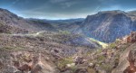
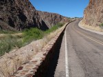
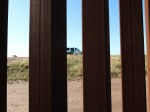
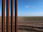
The plans made public for the wall in the Rio Grande valley indicate a fence and a border patrol road to follow the levees that contain the river; much like the sections already in place that wrap around Brownsville and McAllen. These levees are generally on private property and often a good distance from the river and border. So if your property happens to be on the wrong side of the levee, the plans call for it to be condemned, isolated, or bulldozed.

To see what that means we visited three places on the wrong side to talk to people and see what is happening.

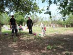
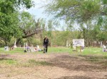
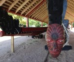
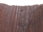
The Jackson Chapel is in San Juan, a suburb of McAllen, and its attached cemetery has been a burial ground for the indigenous Carrizo Indians for millennia before Europeans swept through here. The stones now show largely hispanic graves and there is a small area for veterans from WWI onwards. Today there is a large group of volunteers from the local community and other native American tribes camped in solidarity and ready to resist any construction that might occur. They made us very welcome in explaining what was at stake here and the photographs show the levee right at the back of the graves that would carry the fence and isolate or destroy this site.

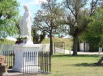
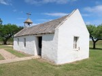
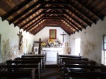
There has been a Lomita Chapel in Mission since 1767 and this one was built in 1865 for the aid and support of traveling missionaries from the Cavalry of Christ serving the local ranches. It is now a delightful public park and place of quiet reflection that is also on the wrong side of the proposed wall. When we visited there was, of course, a ubiquitous white Customs and Border Patrol truck with its green stripe perched on the levee keeping a look out for undesirables. 

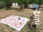
The National Butterfly Center is an educational non-profit also in Mission with about half its land inside the levee providing a hiking path to the wetlands and the river that will all disappear with a fence. The team there told us about a meeting that evening where the local community was planning to meet the ACLU to learn about their rights to prepare for what is next. We found Frances Madeson packing her homemade granola to be handed out at the meeting; she called it “Border Wall Crumble” which has a nice aspirational ring to it as a bumper sticker or hashtag.

When we say “community” here we mean people of color or people with few resources and even less influence; a community that has a history of being ignored by elected officials and abused by people in uniform who act solely for business interests. This is a group that has no history of resistance.

There are a number of fears that the Wall brings into this environment:

– The construction project is a funnel of money with precious little oversight delivered to those who are connected . The costs for a simple fence are astronomical. In addition, the ReadID Act of 2005 gives the Department of Homeland Security extraordinary powers to waive compliance with 48 different laws in order to build a wall. “Clean Air Act? Clean Water Act? Why should a wall damage our water?”

– The wall will make it easier for CBP to round up migrants and asylum seekers and flush them into the for-profit prison industry system where the Supreme Court just said they can be legally detained indefinitely; generating millions of dollars a day of profits.

– The wall will be in America and block access to previously public areas used for recreation or education. The wall with armed guards will then also block access for observation of anything else that is happening on the “outside” of the wall but inside America.

– Because this is Texas, the oil and gas industry is smelling opportunity everywhere and the Jackson Cemetery area is already slated to be a corridor for a gas pipeline and an LNG terminal.

All these points create a recipe for corruption that will last forever. Overall we have a new Border-Industrial Complex that is built on opportunism and cynicism and will be very hard to undo even with a new President and Senate.

Human grief be damned; we’re making money here so get out of the way.

For more on the history of the Texas Rangers read “The Injustice Never Leaves You: Anti-Mexican Violence in Texas’ by Monica Muñoz Martinez

Federal laws waived by DHS for construction of border wall include:

1.National Environmental Policy Act [NEPA]2.Endangered Species Act3.Clean Water Act4.National Historic Preservation Act5.Migratory Bird Treaty Act6.Clean Air Act7.Archeological Resources Protection Act8.Safe Drinking Water Act9.Noise Control Act10.Solid Waste Disposal Act11.Comprehensive Environmental Response, Compensation, and Liability Act12.Archaeological and Historic Preservation Act13.Antiquities Act14.Historic Sites, Buildings, and Antiquities Act15.Wild and Scenic Rivers Act16.Farmland Protection Policy Act17.Coastal Zone Management Act18.Wilderness Act19.Federal Land Policy and Management Act20.National Wildlife Refuge System Administration Act21.Fish and Wildlife Act of 195622.Fish and Wildlife Coordination Act23.Administrative Procedure Act24.Otay Mountain Wilderness Act of 199925.California Desert Protection Act [Sections 102(29) and 103 of Title I]26.National Park Service Organic Act27.National Park Service General Authorities Act28.National Parks and Recreation Act of 1978 [Sections 401(7), 403, and 404]29.Arizona Desert Wilderness Act  [Sections 301(a)-(f)]30.Rivers and Harbors Act of 189931.Eagle Protection Act32.Native American Graves Protection and Repatriation Act33.American Indian Religious Freedom Act34.Religious Freedom Restoration Act35.National Forest Management Act of 197636.Multiple Use and Sustained Yield Act of 196037.Military Lands Withdrawal Act of 199938.Sikes Act39.Arizona-Idaho Conservation Act of 198840.Federal Grant and Cooperative Agreement Act of 197741.Migratory Bird Conservation Act42.Paleontological Resources Preservation Act43.Federal Cave Resources Protection Act of 198844.National Trails System Act45.National Wildlife Refuge System Improvement Act of 199746.Reclamation Project Act of 1939 [Section 10]47.Wild Horse and Burro Act48.An Act of Oct 30, 2000, Pub. L. 106-398, 1, 114 Stat. 1654

The Wall Starts Here.

There are 2,000 miles of the US border with Mexico split about equally between the desert border with California, Arizona, and New Mexico and the Rio Grande river border with Texas from El Paso to the Gulf. About 600 miles of this total distance has some kind of barrier – a wall, a pedestrian fence, or a vehicle barrier.

The very last part of the barrier sits in a private field outside Brownsville; a few hundred yards from the actual river border coming to an abrupt end for no apparent reason. This section was built in 2009 as a result of the 2006 Secure Fence Act signed by George W Bush. The fence still has a number of gaps that allow the actual land owners access to their property but, in 2017 a series of 11 gates were commissioned to allow these gaps to be closed and opened by the land owners. Each gate like the one you see here cost $520,000 even with the powers granted to the Dept. of Homeland Security to waive dozens of environmental laws.

We rode through one of the gaps to see if we could roll along the other side but were immediately stopped by a very polite and friendly Customs and Border Patrol agent. “No you cannot be here. The land is private and the top of the levy is now government property for public safety reasons. No you cannot photograph me having this conversation”.

To add some interesting technology contrast, just a short distance north of this rusting ten year old people herding fence, the launch facility for SpaceX visibly towers over the surrounding landscape.

Before heading out there this morning and leaving the lovely people of Brownsville, we had breakfast at Mariel’s. We met Alice, the daughter of the owner, and chatted to Rosita who told us that her mother fled Mexico, she was born in Brownsville then moved to Minnesota, married a Mexican guy who was then deported, so she moved back to be with her mum.

She said she missed Minnesota but wouldn’t say if she missed the husband.

The Border Starts at the Alamo.

Not physically but historically. All the dominos fall from there. If we are going to ride the border we had better understand its history.

Long before the United States or Mexico existed, everything from here to Patagonia was Spanish; swooped up by the conquistadors, claimed for Spain by the King, and defined as Catholic by the Pope. San Antonio de Béxar was a centre of trade with the native Americans and the Alamo Mission was established from 1718 to educate the converted Indians.

After Mexican independence in 1821 its government sold land in Texas to over 30,000 American and European settlers who increasingly demanded independence from the central Mexican government. The political demands were met with repression that culminated in the Battle of the Alamo in 1836 where the garrison was besieged and overrun and all the Texans – settlers and native Tejanos alike – put to the sword and their bodies heaped and burned.

The Texan leader Sam Houston quickly got his remaining troops better trained, captured the Mexican General Santa Anna, and demanded the independence of Texas as the price for the general’s release. The border was established as the Rio Grande River from El Paso to the Gulf. Border Part One.

The annexation of Texas in 1846 by the United States was then the cause of the Mexican-American War which led to Mexico losing or selling its northern territories to the United States to establish the current land border from El Paso to the Pacific at San Diego. Border Part Two

So … no Alamo, no Texas, no War, no border. Simple.

Three Things Unique to New Zealand – Kiwi, Maori, Kauri (PART TWO)

We were only in New Zealand for a few days but I wanted to do three things you can only do here – see a Kiwi, meet a Maori, and hug a Kauri. These are not as easy as you might imagine.

The Kiwi.

The Kiwi is a flightless, nocturnal bird about the size of a chicken. It’s genetically a mini Emu now endangered due to reduction in its habitat but mainly because it evolved without predators and has been vulnerable ever since the Maori brought pigs and rats the British imported dogs. We visited the Tāwharanui Regional Park that is a peninsula north of Auckland where the Kiwi are protected by an automatic fence that would not look of out place around Jurassic Park. They are serous about protecting their national symbol.

It is almost impossible to see a Kiwi in the wild so we went to Kiwi North, a museum near Whangarei where Kiwis are kept with reversed diurnal cycles – they are kept in near darkness during the day for visitors to have a shot at seeing them and they floodlit at night so they roost. So … we got to see a real Kiwi but it’s still almost impossible to photograph one of the little buggers in the dark.

The Kauri.

The Kauri is a coniferous tree found only in the most northern tip of New Zealand; they emerged in the Jurassic Period (150 million years ago) and still (barely) hang on today and are protected in the Waipoua National Forest.

Nothing prepares you for the sight of one of these monsters as you approach through the rain forest. They are enormous – about 50 feet round and 150 feet tall.  The photos here are of the largest Kauri – Tane Mahuta – and a small grove called the Four Sisters.

Today they are threatened by a fungal infection that has invaded their ecological niche, spread on people’s feet and by feral pigs. To get to see the biggest specimens you have to pass by cleaning stations with brushes and anti-fungal sprays and approach on elevated walkways. 

Not sure if the feral pigs are following these rules.

Three Things Unique to New Zealand – Kiwi, Maori, Kauri (PART ONE)

We were only in New Zealand for a few days but I wanted to do three things you can only do here – see a Kiwi, meet a Maori, and hug a Kauri. 

These are not as easy to do as you might imagine.

First the Maori.  

New Zealand was one the of last places on earth to be settled by humans when Kupe sailed in from Samoa around 1250. He had seen the annual bird migration of the Godwits, figured they must have to land somewhere, followed them to the most northern tip of New Zealand, and found paradise in the Bay of Islands. Six hundred years later the British showed up and started to trade with the (now) Maoris. As a sign of how committed this relationship was, two Maori chiefs were invited to England to meet the King and to work with academics at Cambridge to develop an alphabet for the Maori language in use today.

In 1840 the relationship between Britain and the Maori was cemented in a treaty and that location is now the most important Maori historic site in the country – the Waitangi Treaty Grounds. The treaty is still technically in force and still being debated today. Our guide was Nate (nah-tay) Kana who claims to be descended from one of the signatories to that treaty but anyone who can prove their Maori lineage back to the 1860 census is legally Maori – now about 600,000 (15% of the population) mainly concentrated in the North Island near where they originally landed.

The Maori are a large share of the poor of New Zealand but, from the start, the British had a very different relationship with the Maori than with the Aboriginal population in Australia – one was a trading partner the other a victim of genocide – and the racist vibe is still only felt in Australia. The Maori also help New Zealand win at rugby – maybe that’s a factor too.

The Ceremonial War canoe was built in the 1950s and is launched every year on the anniversary of the treaty. It was renovated in 1974 for the Queen’s visit and after she rode in it, she designated it “Her Majesty’s Ship” so it’s now part of the Royal Navy.

If You Don’t Preserve It – You Don’t Deserve It.

The creation myth of the aboriginal people is a charming and seductive story.

In the Dreamtime, everything was already there under the surface of the earth and came into being because the ancestors broke through and made things real by describing and singing about them. Everything – rocks, plants, rivers, insects – came into being through song and will return from view if we do not continue to revere and sing about them. If we don’t preserve it, we don’t deserve it.

This is complete nonsense, or course, but so is the basis for every religion. The idea of God creating heaven and earth and resting on the sabbath, or that God spoke through a shepherd in Mecca or Joseph Smith in New York, or that Gaea and Chaos procreated to create darkness and light. And don’t get me started on Brahma and Vishnu and Shiva. Too many gods; they cannot all be right.

When the Christian British arrived here they obviously thought that the “natives” were worthless lazy hunter-gatherers with no culture and no religion and no law. But the real Australians had been managing this land and practicing according to a consistent law for 60,000 years before white people were even white. Myth and law and tradition here have been combined for millennia.

Aboriginal clans have obviously fought over things but they also exchange important tokens to cement a common understanding of how interdependent we all are. There were territories but no fences. There is the idea of “tenderrum” which welcomes others when needed on the assumption that they would leave afterwards.  Land wasn’t something controlled and traded with deeds but a common resource that everyone has a responsibility to maintain and share. Just because aboriginals were wanderers does not mean they had no idea of responsibility; all the country was linked by songlines and “ways through” that had to be maintained and respected.

There’s a lot to learn from this as we look at climate change, and population growth, and water shortage and all their consequences.

Oh, and every other religion has produced terrorists in its name – but not here.

The photos are  of Uluru in a rainstorm including the astonishing sight of a standing lenticular wave over the rock. Also the petroglyphs near the head of the Kuniya trail when you can see the image of the sand python who created Uluru high on the wall of this canyon.

Uluru In The Rain

The parks department and the traditional owners of this land are careful to point out that there are two possible explanations for how Uluru (Ayers Rock) got here.

The geologists say that Uluru is the small tip of a six kilometer thick layer of very hard sandstone made from eroded granite that was laid down over hundreds of millions of years in a shallow sea and then distorted and eroded and twisted again over a few more hundred million years.

The indigenous Anangu people, for whom this site is sacred, believe that the sand python laid her eggs a few kilometers from there at Kata-Tjuta and then came over to Uluru to build a safe place and go to ground and left her shape and mark on the landscape.

I like both stories. You decide. Millions of years are hard to imagine.

I arrived here this afternoon and took off to drive around the rock a couple of times in each direction. As the day wore on, a few different storms passed through and you can see the little rivers of water cascading off the south side. 

Then the rain started again and made a wonderful double rainbow visible in the evening from the sunset viewing area.

An amazing afternoon.

Bury My Heart at Butchers Creek

In almost a month of traveling in Australia, it has been almost impossible to have a conversation with, or even a conversation about, indigenous aboriginal Australians. Those we have met are not interested in tourist chit chat and everyone else doesn’t know how to discuss the subject.

When I ask today’s Australians about the original Australians I get a range of responses. First there is the self avowed racist “They are only a percent of the population and what can we do anyway? What would this country have been if we hadn’t shown up, want us to stay in the stone age? And it’s stupid that someone who is only part aboriginal can claim all their rights” (see footnote)

Then we have the wholly patronising “We can’t just give them money as they’ll just spend it on booze and gambling”. Leave aside the fact that every pub in Australia has a betting shop and a room full of poker machines called pokies for booze and gambling of all sorts.

Finally we get the more realistic fatalist shrug that still leads nowhere … “Not sure we know what to do frankly. It’s a problem”.

Riding around Victoria this past week, it strikes me that one thing might be to actually recognize the events of the past and memorialize them.

The US 7th Cavalry massacred 300 Lakota indians at Wounded Knee. This is now a Historical National Landmark and the US Congress officially apologized in 1990 on the centenary of the event. In Victoria alone there were dozens of Wounded Knees in the mid 1800s. We have passed through a number of these places and I looked for any historical markers but didn’t find any.

When you read the Gippsland lifestyle magazine it is full of arty towns and horse riding advice and wine festivals but Victoria was also the epicentre of the clash between white squatters and the indigenous people. So much so that there is a wikipedia page dedicated to the Gippsland Massacres but there were atrocities all over the state – none of which are memorialized anywhere. It is hard to find ANY information actually; the closest is a document from the 1990s that was compiled for the Koorie Heritage Trust twenty years ago – shown here.

A classic example is in Benalla whose Wikipedia entry mentions the Faithful Massacre in which a handful of settlers died in an argument with the indigenous people but fails to mention the hundred or so locals who were slaughtered in reprisal by Angus McMillan. When you visit Benalla on the Broken River where these events took place next to the town historical museum, there is a plaque commemorating … you guessed it … Ned Kelly.

Yes, Australia has made huge strides to recognize traditional owners of the land and that was then and this is now. But just because nobody wants to remember, you can be sure that these stories are now woven into the oral histories and collective memories of the original Australians.

Footnote – This person was half right – Indigenous Australians are 3.4% of the population and in Victoria you can claim aboriginal status if you have 1/32nd original blood.