The Melbourne Festival – Tanderrum

My first day in Australia was the first day of the Melbourne Festival with both Portland and family connections for me. The former Artistic Director for the Melbourne Festival was Kristy Edmunds who created the Portland Institute for Contemporary Arts and then moved from Portland to do the same thing – but bigger – here. At that time, Kristy’s patron was my cousin Penny who ran Arts Victoria for the Premier of the State; essentially the cheque book for the festival. Small world even over thousands of miles.  

Melbourne connects to Portland via Sutton-in-Ashfield, Nottinghamshire.

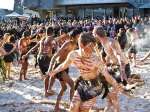
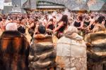
The opening performance for the festival was Tanderrum a ceremony that brings together the five aboriginal clans that have lived here for hundreds, if not thousands, of generations; a ceremony that had been hidden until recently since the British arrived two hundred years ago. The ceremony celebrates spring and the agreement among these groups to allow each other on their lands temporarily to hunt and fish. A lot like Tom McCall’s dictum about Oregon; you are welcome to visit but please don’t stay.

Two things struck me about this event. First, the participants were not all obviously aboriginal due to a long time of mingling and mixing with new arrivals. Apparently, in Victoria you are allowed to claim first people status even if you are only one 32nd aboriginal; a source of anger for the conservative end of the political spectrum. 

Second, the festival was very visible about needing permission to photograph the event due to cultural sensitivities. In the US, I am sure this performance would have been surrounded by a Christmas tree of lit up iPhones snapping and posting to Instagram but here – nothing. Not a single camera in evidence. Which is why I stole the attached photos from the official festival site – the event I saw was identical as you would expect. 

However, as I left, I heard a lady complaining to her friend that she was “a bit disappointed because it was the same as last year”. Well I’m sure it’s been the same for the last 60,000 years; it’s not a bloody rock concert where you expect them to play the new album.

Magical Oregon Moments

“In A Landscape” is a series of piano recitals performed by Hunter Noack in some of Oregon’s most scenic places. He hauls a 1912 full size Steinway to iconic places in the open air and the audience listens through wireless headsets. You can sit by the piano or wander for miles and still get the impression that he is playing just for you – an amazingly vast but intimate experience.

The last of this year’s concerts was on the Alvord Desert – a dry lake bed nestled under the Steens Mountains in Eastern Oregon surrounded by magic light and stunning vistas where we camped in perfect weather. The audience was remarkably diverse for a classical music event – from Portland hipsters to local ranchers who had taken their time and their heavy equipment to make this special performance possible. Hunter apparently values the unexpected interactions after his concerts and this event was no exception – after a couple of beers and the offer of our tequila, a lot of fun conversations followed into the night as most people were staying right there in one form of camping or another.

Included in this event was a visit from Kim Stafford, the Oregon Poet Laureate. The second photograph is of Hunter Noack listening to Kim Stafford read “In The Desert” that the late Ursula Le Guin wrote about the Alvord. Not a dry eye in the house.

Mark your calendars for 2019.

Grapes of Wrath – 2018 Edition

Riding Route 66 seemed like a great time to read The Grapes of Wrath.

The changing geography fitted nicely into understanding both the fictional lives of the Joad family and the experience of the migrants in the 1930s. All the places mentioned in the book are still there, obviously, but some have fared better than others – those dependent on Route 66 like Glenrio, Texas are now dead; those built on agriculture or oil like El Reno, Oklahoma are doing just fine today.

The themes of the book are as relevant today as they were 80 years ago — In the late 1930s dust bowl, small farmers were driven from their land by climate change, industrial agriculture, and debt. Five hundred thousand became refugees and fled westward in a desperate search for work and a new life for their families. When they arrived they were denigrated and exploited by another group of big landowners that had already stolen California from Mexico and already imported their own cheap labor. This is happening the world over today and is still happening in America where we may yet see a repeat of the 1930s.

In two generations, the real and fictional farmers on the plains had slipped from being land owners to tenants to laborers as they borrowed to support their failing farms and were then turfed off by the banks. In Oklahoma they farmed corn and wheat and grew vegetables for themselves. In California, they had a different experience – even though they were still working in the fields their degradation continued.  “A man may stand to use a scythe, a plow, pitchfork; but he must crawl like a bug between the rows of lettuce, … he must go on his knees like a penitent across a cauliflower patch”

Rolling through Oklahoma and the Texas panhandle with howling hot dry winds it was easy to see how the dust bowl could happen. One of Steinbeck’s characters said “Maybe we oughtn’t a broken up the land”. Today the land is pockmarked with hundreds of fracking tanks and the land is held together by irrigation. But this area is in a ten year drought so groundwater is just fending off another catastrophe. The Ogallala aquifer is running out of water fast but industrial agriculture can’t slow down – the shareholders won’t allow it. These are exactly the same forces that drove the Joads from their land. Only a matter of time.

Once you leave the plains heading west, Route 66 heads into New Mexico and Arizona and the Mojave Desert – a truly brutal environment – and it is painful to imagine a 1935 journey across this heat and this landscape in a broken down car cut apart with a truck bed with a failing motor and no money for food, let alone tyres and repairs. None of us really understands the migrant experience.

At Barstow the Joads headed north to the Central Valley they thought was going to be salvation. They went to Bakersfield, to shanties, and into poverty. Less than10% of the migrants stayed in California and most drove back.

We continue on Route 66 from Barstow to Pasadena and Santa Monica with lots to think about.

The map shows the fictional route of Tom Joad and his kin – Route 66 from Oklahoma to California. The colored shapes show the extent of the dust bowl – it started small in 1935-36 where Kansas meets Texas but spread across the plains by the end of 1938 before shrinking back to where it started by 1940.

Magnus Walker – Porsche Collector

Sitting having lunch at Zinc Cafe in downtown LA, this guy was at the next table. Some people in LA are looking for film stars; others are looking out for Porsche icons.

We chatted for a little bit, he comes from Sheffield which is a few miles up the road from where we grew up, and Magnus asked us if we’d like to come over and kick some tyres as his building is right behind the cafe. He was incredibly generous with his time and gave us the complete tour of his home and garage and Porsche collection.

Magic moment in LA with a design icon.

Route 66 versus Interstate 40

“Thanks to the interstate highway system, it is now possible to travel from coast to coast without seeing anything.” Charles Kuralt.  

In the battle between Interstate 40 and Route 66 – the Interstate won.

From Oklahoma City to the Pacific, Route 66 became the major road to the west following the route of the Beale’s Wagon Road built in the 1850s (using camels as pack animals but that’s another story).

Before heading west everything converged on Oklahoma. The Ozark Trail, the Santa Fe Trail, even the Trail of Tears – they all funneled in from the south and the mid-west. After WWII, traffic grew exponentially and created hundreds of small local businesses along the road catering to the increasingly affluent travelers. Snazzy diners and motels at every point of interest. Cheap food and clean sheets. Individual businesses before the corporate giants took over.

Many of these places are still giving the whole route a 50s vibe. But the road is also littered with the skeletons of most of these businesses as Interstate 40 just obliterated them. Whenever I-40 exits were placed close to an existing town, then maybe the businesses survived. But even in towns like Tucumcari which has become the hip-retro motel town with the Blue Swallow and it’s original “refrigerated air” sign, there are new Holiday Inns and MacDonalds dropped in between the hulks of failed hotels and truck stops. The old truck stop went bankrupt, Shell or Mobil or Chevron pulled off their logos, and left the building to rot and left the toxic tanks in the ground. It is amazing to still see places that were clearly abandoned thirty or forty years ago.

(By the way, every one of these companies has a Corporate Responsibility statement on their web sites but I suppose that doesn’t include cleaning up after themselves in small town America “the communities where we operate”. Hey, we bus our own tables, why can’t Mobil or Texaco clean up ?)

You can see this all along Route 66 and some towns resemble Chernobyl – like everyone just left the radioactive mess behind. This is most pronounced on the section from Seligman to Kingman, Arizona where I-40 took an entirely different southerly route and Route 66 became a distant backwater. The only Route 66 business here is the Hackberry Store which just became a gift shop caricature of itself and an Instagram magnet. 

Overall the ride has a truly unique feel because of these relics whether they are hanging on or not. 

————————————-

Chevron’s Corporate Responsibility Statement:- Affordable energy is a catalyst for economic growth and prosperity. Our company’s values drive us to provide that energy responsibly while protecting the environment and working with our partners to strengthen communities because our success is tied to the success of the communities where we operate.

Will Rogers Memorial, Claremore, Oklahoma

If we want to play the “People I’d love to go back in history to meet” game, then Will Rogers would be very high on my list.

A Cherokee cowboy turned vaudevillian with his rope tricks; his wit on stage made him a successful humorist; his popularity led to a movie career in silent and feature films; as a newspaper columnist and non-partisan social commentator he reached 40 million readers every day and his radio shows got to everyone else. He traveled the world and was the first civilian to fly coast to coast with pilots on the first air mail flights. He supported efforts to get people back to work in the depression working for President Hoover. His end came too soon in a plane crash in Alaska when he and Wiley Post were exploring routes from the west coast to Russia.

The Will Rogers Memorial Museum is in Claremore on land that he bought for his retirement home. It’s a small place but does an excellent job of telling his amazing story with taste and humour.

Here is a photo of his notes for a 1931 radio address that seems all too relevant today …

“Now we read in the papers every day, and they get us all excited over one or a dozen different problems that’s supposed to be before this country. There’s not really but one problem before the whole country at this time. It’s not the balancing of Mr. Mellon’s budget. That’s his worry. That ain’t ours. … There is no other one before us at all. It’s to see that every man that wants to is able to work, is allowed to find a place to go to work, and also to arrange some way of getting a more equal distribution of the wealth in country.

Now it’s Prohibition, we hear a lot about that. Well, that’s nothing to compare to your neighbor’s children that are hungry. It’s food, it ain’t drink that we’re worried about today. Here a few years ago we was so afraid that the poor people was liable to take a drink that now we’ve fixed it so they can’t even get something to eat.

So here we are in a country with more wheat and more corn and more money in the bank, more cotton, more everything in the world—there’s not a product that you can name that we haven’t got more of it than any other country ever had on the face of the earth—and yet we’ve got people starving. We’ll hold the distinction of being the only nation in the history of the world that ever went to the poor house in an automobile.”

Picher, Oklahoma: A Uniquely American Disaster.

Think of a ghost town. You’ve maybe been to Bodie in the Sierra Nevada or Silver City in Idaho. They look old, Victorian, wooden, antique. Abandoned a long time ago; the Dust Bowl, the Depression. But that is not the case for Picher, Oklahoma right on Route66 which was finally left empty in 2015.

Lead and zinc mining started here in 1913, the population peaked in the 1920s and then slowly declined to the 1960s when mining stopped. Having produced over $20 Billion worth of ore, this was the largest lead mine in the world. The original company wanted the lead for paint but this one field produced half the lead and zinc used in World War I and over 80% of its output went to make munitions in WWII.

By the 1970s, water had flooded into 14,000 abandoned mine shafts and over 70 million tons of toxic tailings and was now running into Tar Creek and the local water supply. It wasn’t until the 80s that the area was declared a Superfund Site by the EPA and mitigation started, But people stayed on in Picher and thought the place was a great place to live and bring up their children who were swimming in the sink holes and sledding down the waste piles. They thought the skin colouration was sunburn but it wasn’t. It took to the 1990s before half the kids were found to have dangerously elevated lead levels. On top of that the buildings started to collapse and the Corps of Engineers judged 90% of them highly unsafe.

The EPA and Engineers said it was time to move. This is America’s most toxic town. The government offered to buy every house; today most of the buildings have been demolished but some still remain.

In one last nauseating twist to this tale, the land was originally leased from the local Quapaw and Miami tribes who received very little of the wealth created but who are now being asked to take their land back.

We can have a healthy debate about the role of government versus the private sector, but this story has been repeated thousands of times – company extracts wealth, pays shareholders, then leaves taxpayers to pick up the consequences. Buildings can be bought but the health consequences are forever.

Photos: Remaining housed in downtown and some Google Earth pictures of the town showing the huge dunes of waste material and the sinkholes surrounding the school.

Gateway Arch – The Eiffel Tower of St. Louis

The Gateway Arch is truly breathtaking – we rolled into town on Route66 from the east in torrential rain and it framed the view of the city and the storm across the river – from downtown it dominates your attention and anchors everything.

When you enter the underground visitor gallery you are surrounded by projections and pictures that celebrate the arch as a product of the 60s construction – when Kennedy was sending us to the moon and Martin Luther King had a dream; the boldness and energy of a confident America.

But the thinking and impetus for this project dates back to the Depression and the design competition was started when World War II was not yet over. This makes the result even more compelling. The initial commitment was sealed with appropriations signed by FDR in the 1930s from the same WPA job creating funds that built Timberline Lodge and paid for Woody Guthrie. The design competition was started in 1944 and awarded in 1947 to the Finnish-American architect Earo Saarinen. Imagine the reaction to a building whose design was a hyperbolic cosine function when people were driving Grapes of Wrath era Hudsons.

The trip to the top is in a small oval capsule where you might meet Jodie Foster in the movie “Contact” and the slit windows are angled to deliver perfect views from 630 feet.

The project did not create anything like the promised 5000 jobs but the revitalization of the city has been estimated to generate $500M of other new construction. Who wouldn’t want their hotel or stadium or office under or near this staggering symbol.

Photos: The Gateway Arch and the Old Cathedral Basilica of Saint Louis from my hotel window – Loved being able to see the quality of the welds in the stainless steel outer skin – shadow of the arch across downtown St.. Louis – the Soviet looking bas relief mural celebrating the builders of the arch.

Finally the mathematical expression of the building “where fc = 625.0925 ft (191 m) is the maximum height of centroid, Qb = 1,262.6651 sq ft (117 m2) is the maximum cross sectional area of arch at base, Qt = 125.1406 sq ft (12 m2) is the minimum cross sectional area of arch at top, and L = 299.2239 ft (91 m) is the half width of centroid at the base. The triangular cross sectional area varies linearly with the vertical height of its centroid.” 

Obvious.

Harley Davidson Museum

Every Harley Davidson ride from Chicago, apparently, has to include a trip the Harley Davidson Museum in Milwaukee for an education, a benediction, and a tee-shirt. So Mick Sumpter and I made the pilgrimage before setting off on the Route 66 ride to Santa Monica.

In 1903 William Harley and Arthur Davidson put an engine in a bicycle frame and drove the rear wheel with a leather loop strap. Apart from the V-twin arriving in 1907, nothing much has changed. The museum really is an excellent experience even for those of us who have not yet drunk the HD cool-aid – well presented serious history that covered the bikes, the business ups and downs, and the unique brand without a huge amount of marketing hullabaloo. (That’s reserved for the gift shop)

Just to show that there are always connections in this small world, William Harley’s father came from the small village of Littleport, about ten minutes from Mick’s home in Cambridgeshire where there is now a Harley statue by the church to celebrate the connection. 

Back to Milwaukee … 

By the time HD had got into full swing and established a large presence in Milwaukee, there were over 150 manufacturers of motorbikes in the US – only a dozen made into the 1920s and only two (HD and Indian) survived the Great Depression.

I get the attraction and the mystique of these bikes and why so many people have been life-long devotees. This is my first real distance ride on a Harley – we are on two matching brand new Electra Glides – but I am not yet converted. It feels like a piece of agricultural machinery to me (clunky gear shift, poor low end torque), the build quality is not perfect, and the riding position is just not really comfortable as you cannot move around the bike or lift your backside periodically. 

Let the hate mail commence.