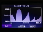

Trips Are Lines on Maps – We always describe our trips as lines on a map; a two dimensional plane of north, south, east, and west; journeys across a Mercator Projection. But sometimes the vertical section of our travels tells a better story. This is the histogram from my GPS that tells the vertical history of our day that started at dawn over Wallowa Lake and finished with a descent to the Snake River described by one of our gang as “fucking terrifying”. It just doesn’t get any better than that – now does it?
Today we left Wallowa Lake Lodge and swept down to Imnaha wedged against the eastern edge of Oregon. From Imnaha we climbed dramatically to get to Hat Point and the site of an abandoned fire lookout tower with breathtaking views across Hells Canyon and down to the Snake River 5700 feet below. Then the symmetrical return to Imnaha and a beautiful ride climbing up the Imnaha River with a final surge up to the Hells Canyon Overlook. Finally we discovered Hess Road which is a very loose set of dirt switchbacks that plunges 4500 feet in about 3 miles down to the Snake River with staggering views up and down river.
That was the “fucking terrifying” part. When all the turns are towards the abyss and there is little or no traction, you realise just how powerful a force is gravity acting on 800 pounds of adventure bike with adventure rider.
What a great day on a motorcycle.
PS: Some idiots had moved the white stones at Hat Point to say something else. This brought out the boy scout in Jenson Beeler who put them back again in a great act of reverse vandalism.
