

“Ideas without precedent are generally looked upon with disfavor and men are shocked if their conceptions of an orderly world challenged.”
j Harlan Bretz.
The story of the Channelled Scablands is the story of one man fighting both the establishment and conventional wisdom.
Since the mid-1800s the recent geology of the earth had been settled. The land around us was made by a few violent episodes and then by small changes happening over unimaginably long periods of time – the earth’s crust being twisted by pressure and eroded by millennia of rains and winds. It’s called uniformitarianism.
But when J Harlen Bretz stood on the edge of the Potholes Coulee near Quincy, Washington in 1923, he could only explain the canyons ripped down to the Columbia River as the result of a violent flow of water – we now know it’s the result of the Glacial Lake Missoula floods inundating this basin before leaks developed and the escaping water and ice and rock scoured the coulees and the Columbia Gorge to let the water get to the Pacific. This did not align with settled science to the academic geology “establishment” dismissed Bretz and his hypothesis for decades. How could you have biblical floods in a desert?
Riding around Central Washington now it is easy to see the results of the Missoula Floods. As the polar ice caps came and went from 15,000 to 18,000 years ago, water was trapped east of the Rockies for huge amounts of time. As these ice dams burst they released immensely powerful floods. This happened over 80 times and now we see a huge debris field and a scoured landscape.
For Bretz, it was only decades later, with a better scientific understanding of the Ice Age, that he was vindicated. In his 90s, he commented that he was pleased to be proven right but that he had outlived all his critics.
Photos:
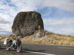
Yeager Rock – as the Missoula Floods poured across Washington, they carried rocks torn from the underlying basalt – some rocks were huge and were rafted on the ice and finally dumped hundreds of miles away and the ice melted.
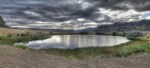
Dry Falls was once the largest waterfall in the world – with 400 feet of water plunging and tearing a path south across a rim many miles long. Now here we have Dry Falls Lake looking down the coulee towards Ephrata.
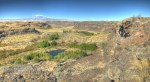
Potholes Coulee is the lowest point on the edge of the Quincy Basin where the water found an exit and scoured out these massive canyons and sheer cliffs down to the Columbia River.
Potholes Coulee from one side to the other with Mike Malone on the right edge.
Tamer Riad and Mike Malone on the edge of the Potholes Coulee.
