What Are These Blobs in the Andes? …. The llareta plant (pronounced yah-ray-ta) is a member of the Apiaceae family which means it is related to parsley, carrots, and fennel. It is found uniquely high up in the Andes and we found these examples at about 14,000 feet on a section of Ruta 40.

They look like blobs from a distance but are rock solid and feel almost like coral to the touch. They grow by absorbing what little humidity they find occasionally in the air. They also grow extremely slowly, maybe a centimeter per year. There are examples in this area that could have been there for 3000 years.

The ones that we found here are certainly old enough to have been growing before Queen Victoria was born.

Ain’t evolution wonderful?

The Third World – They Do Things Differently There …… It took four hours for us to get riders through immigration and bikes through customs when we crossed from Peru into Bolivia the other day, and we still had the support truck impounded for an alleged irregularity in Bolivia a year ago. Don’t ask – it’s a long story.

So we got some time to sit and watch the comings and goings across the border and saw a constant stream in both directions of small pedal carts moving a few hundred pounds of stuff at a time – potatoes, toilet rolls, grapes into Bolivia – bricks, eggs into Peru. Every one of these carts being pushed by drab men in Premier League team shirts and ladies in traditional Quechua (pronounced ketch-wah) dress – multiple layers of skirts, woolen cardigans, and the stylish bowler hats – adopted from British railway workers in the 1920s; I kid you not. These ladies also always wore a multi-coloured shawl wrapped around their shoulders to carry something – clothes, groceries, a child. Always there and always full of something,

This ant-like flow is due to the fact that it could take days of waiting, paperwork, or handouts to get the actual trucks across the border. So, as we came into town, we saw a dozen 72 foot trailers of potatoes being unloaded and transported cart by cart to the same number of trucks on the other side which were disgorging something else to be carted over to Peru. Clearly these hundreds of labouring souls are cheaper in the Third World than the time and inconvenience of agreeing a functional border process.

There’s money under that salt … Lake Uyuni in Bolivia’s Altiplano is the world’s largest dry salt lake – over 4000 square miles – that’s more than twice the size of the Great Salt Lake in Utah. We got to explore very little of the expanse but it is easily possible to ride out far enough to lose sight of the hills and only see the curvature of the earth. Remember to bring a compass if you try this.

We stayed at the Hotel Palacio de Sal where the hotel and most of the furniture, including the beds, are made of salt quarried from the surface of the lake; each room like an igloo of salt complete with your own stalactites.

The lake is level to within one meter across the entire surface and, because it is such a large target and almost never masked by clouds, is used as an altitude reference for earth observation satellites. Under about 20 feet of salt at the surface, there is a lake of brine that contains 50-70% of the world’s supply of lithium. In the new battery economy this could transform Bolivia from its position as the poorest South American country*

* Poorest ranked by GDP(PPP) per head – http://en.wikipedia.org/wiki/List_of_South_American_countries_by_GDP_(PPP)_per_capita

Bolivia Fuel Stories … First impressions can be misleading …. The Bolivian government subsidises gasoline to the consumer. Don’t ask me why a government would choose to give away money when other governments raise money on fuel sales – maybe Evo Morales wants to be El Presidente For Life. In any event, Bolivians pay around $2.50 per gallon but foreigners have to pay $6.75 a gallon in round numbers.

When our bunch of motorcycle riders ride into town speaking English and riding bikes registered in Argentina, there was precious little chance of us getting the local price. The resulting situation usually ended up with one of the following reactions …

A) Bugger off, we don’t serve foreigners. This was our first encounter, at a rural truck stop, and we didn’t get off on the right foot vis a vis Bolivia.
B) We can sell you fuel at the higher rate but I need to see your passports and take 20 minutes to fill out a form. This was in the capital La Paz where perhaps there are a few officials to check that the process is being followed.
C) We can sell you fuel at the higher price, so step right up. This was pretty much everywhere else around the country.

We did, however, have one other experience. Arriving in Uyuni before launching off into the unknown, we found a gas station with lots of gas, no attitude, but no electricity. Our guide then took off for a little tour of the town and found a local garage mechanic and his wife who were willing to sell us 50 gallons of their personal stash for around $5.50 a gallon which was an amazing deal for everyone – he got to double the local price in cash and we got to roll on with no hassles.

The encounter was perfectly charming. The gent and his wife are 73 years old and she told us her immaculate complexion was due to only washing in cold water, we met his parrots who both greeted everyone with “Ola!”, and he gave us gifts of ore from the manganese mine he used to work at.

All in all a much better memory with which to depart Bolivia than the one on our arrival. We will be back.

Death Road Bolivia – But Nobody Died …. The North Yungas Road is a section of the route that connects the Amazon rainforest region of Bolivia (where all the legally grown coca comes from) to the capital La Paz. It was built in the 1930s by prisoners of war during a war with Paraguay and became legendary when the Inter-American Development Bank rated it as the “the world’s most dangerous road”; with clear ustification as the core part is a single track perched above an abyss into the rainforest into which many vehicles per year have plunged.

Today the most dangerous section, that we rode, has been replaced by a more modern set of viaducts and tunnels. But this original part is a road that still demands 100% of your attention. We started in dense fog at 13,000 feet and dropped to 3,000 feet in about 20 miles of tortuous, narrow, wet turns over terrifying drops.

An absolute blast from start to finish.

Along the way, I stopped to take a breather in some shade and met Samuel who strolled up to chat and wanted to know about the BMW R1200GS that I am riding; a much more imposing machine than the Pegasus that Samuel uses to transport him, his wife, and kid. In his Spanish and my pidgin, we discussed a few things. Finally he asked me what the BMW cost and I told him that he’d have to pay about $35,000 to get one in Bolivia. To which Samuel whistled loudly and said “Aye, es un camion” (That’s the price of a big truck)

Yes you could buy a big truck but it would not be as fun on the Death Road.

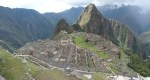
Machu Picchu – Summer Palace of the Inca Kings. But what else was going on in 1450.

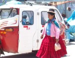
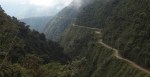
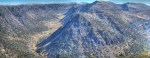
….. There is no doubt that Machu Picchu is a magnificent sight and wonderful reason to visit Peru. It was built around 1450 as a summer retreat for the Inca kings whose capital was in Cusco about 65km away. It was a trek then and it is a trek now as the only way to get here is by narrow gauge train down the Sacred Valley of the Incas and then by terrifying shuttle bus up the last 3000 feet to this col in the Andes.

The Incas grew to dominate from the Andes to the Pacific from the around 1250 to 1450 when they ruled by alliances, marriages, or force over 12 million people across modern Peru, Chile, Ecuador, Bolivia, and Argentina. When the Spanish showed up, that all changed. The King knew a losing proposition when he saw one and disappeared leaving his attendants to fight over Machu Picchu and quickly to abandon it. The Spanish didn’t even know it was here and it was only “discovered” again in 1911 by an enterprising American archaeologist, Hiram Bingham. Serious archaeology didn’t start until the 1970s.

But, despite its power and grandeur, the Inca kingdom was essentially primitive. In the late 15th century,, when Machu Picchu was built, what was happening elsewhere? Well in Europe this was in the full flowering of the Renaissance, the Medici Palace was built, the Forbidden City, half of the cathedrals we visit, Leonardo da Vinci, the Chateaux de la Loire, and, obviously, well powered armies and navies that had a profound effect on South America and the Incas.

It’s good to be King but it’s better to have technology.

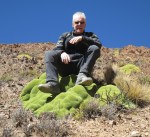
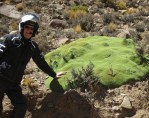
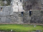
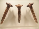
The other two photos: two preservationists cleaning Machu Picchu with toothbrushes, I kid you not, and war clubs that were in current use by the Incas when Pissaro showed up. (From the excellent Museum of Precolumbian Art in Cusco)

The Nazca Lines – We understand HOW but we have no idea WHY.

The lines are a series of geoglyphs in southern Peru – built by the Nazca people between 400 and 650 AD. The images are made with shallow trenches that expose the lighter coloured rock beneath and modern research suggests they would not have been difficult to realise even with simple tools and surveying. So that’s HOW they did it.

But we have no idea WHY. It has been proposed that they are signs to the gods in the sky, or constellation maps, or offerings to gods associated with water. From there the suggestions get a little more bizarre – landing strips for aliens, looms for ritual material making, and ideas that the Nazca must have had hot-air balloons to be able to get the perspective to build them. Bottom line – we have no bloody idea why they are there.

These photos were taken from a late afternoon flight in a Cessna 206 (the workhorse of third world aviation) and show one of the geometric shapes, a hummingbird, the monkey (whose spiral tail has become a national symbol for Peru), and strangest of all, the spaceman which looks like ET with ski boots on a hillside.

Check one more off the Bucket List.

Oregon is a Wonderland – Just back from a quick 1000 mile drive to the bottom right corner of Oregon. Portland to John Day via the Painted Hills, Blue Mountains to Burns to Frenchglen, the Steens, Hart Mountain, and back home via Summer Lake and Bend. 

Impossible to photograph but here are some snapshots  … Antelope wandering across the Hart Mountain Refuge, an evening view of the Steens from Frenchglen, a lunchtime picnic spot looking up Big Indian Gorge on the south side of the Steens. 

Kam Wah Chung – If you ever find yourself in John Day, Oregon, take the time to visit Kam Wah Chung. In the 1880s, two Chinese immigrants set up their business – a general store, doctor office, and herbalist shop to support the local mining community in the fading days of the gold rush but still the largest Chinese population in Oregon.

Ing Hay was a herbalist and practitioner of “pulse diagnostics” and Lung On was a shewd bilingual merchant. Together, they worked in this small combined store, medical office, flop house, and kitchen until their deaths in the 1940s. At that time, as they had no immediate relatives in Oregon, the place was just locked up and abandoned. Their distant Chinese families were not allowed to leave a China occupied by Japan, and the US government would not allow money to be remitted out of the US to its new enemy.

When distant cousins gifted their land to the City of John Day and the old store was opened in 1968, a veritable time capsule was discovered and that is essentially what you see today – nothing added and nothing removed with reminders of the Chinese products they imported with the local staples they provided.

The narration of the visit whitewashes a great deal of the ugliness of the past but the story of how they left behind family, could never leave without losing everything, the discrimination and exploitation including the Chinese Exclusion Act of 1882 is complex and moving and well worth reflection.

There is great OPB Oregon Experience documentary of the time and you can find it here … http://watch.opb.org/video/1207317935/

Trips Are Lines on Maps – We always describe our trips as lines on a map; a two dimensional plane of north, south, east, and west; journeys across a Mercator Projection. But sometimes the vertical section of our travels tells a better story. This is the histogram from my GPS that tells the vertical history of our day that started at dawn over Wallowa Lake and finished with a descent to the Snake River described by one of our gang as “fucking terrifying”. It just doesn’t get any better than that – now does it?

Today we left Wallowa Lake Lodge and swept down to Imnaha wedged against the eastern edge of Oregon. From Imnaha we climbed dramatically to get to Hat Point and the site of an abandoned fire lookout tower with breathtaking views across Hells Canyon and down to the Snake River 5700 feet below. Then the symmetrical return to Imnaha and a beautiful ride climbing up the Imnaha River with a final surge up to the Hells Canyon Overlook. Finally we discovered Hess Road which is a very loose set of dirt switchbacks that plunges 4500 feet in about 3 miles down to the Snake River with staggering views up and down river.

That was the “fucking terrifying” part. When all the turns are towards the abyss and there is little or no traction, you realise just how powerful a force is gravity acting on 800 pounds of adventure bike with adventure rider.

What a great day on a motorcycle.

PS: Some idiots had moved the white stones at Hat Point to say something else. This brought out the boy scout in Jenson Beeler who put them back again in a great act of reverse vandalism.